
 Search
 Feedback
 About UniCat
  Help
Help News
News
| Listing 1 - 7 of 7 |
Sort by
|
Book
Year: 2009 Publisher: Washington, D.C., The World Bank,
Abstract | Keywords | Export | Availability | Bookmark
 Loading...
Choose an application
- Reference Manager
- EndNote
- RefWorks (Direct export to RefWorks)
This paper uses a rural household survey dataset collected in 2006 and 2008 to investigate the impact of a market-based land resettlement project in southern Malawi. The program provided a conditional cash and land transfer to poor families to relocate to larger plots of farm land. The average treatment effect of the program is estimated using a difference-in-difference matching technique based on propensity score matching; qualitative information complement the analysis to ensure unobservable characteristics do not bias the findings. As expected, the results show a significant effect on landholdings and agricultural production, with land size increasing and maize production increasing by more than 100 kilograms relative to the control. However, the impacts on food security and asset holdings were mixed. Households that relocated great distances had systematically lower impacts than those households that stayed within their district of origin because they had to adapt to unfamiliar agro-ecological, cultural, and market environments. Impacts also varied across gender of the household head; female-headed beneficiary households increased their productive and consumption assets significantly, while male-headed households increased their asset holdings less so.
Agricultural production --- Arable land --- Capital formation --- Comparative analysis --- Cultivable land --- Debt Markets --- Economic growth --- Economic Theory and Research --- ECONOMIC WELFARE --- Economics --- Effective use --- Environmental --- Environmental Economics and Policies --- Environments --- Expenditures --- Finance and Financial Sector Development --- Financial resources --- Labor inputs --- Land productivity --- Market prices --- Policy makers --- Poverty Reduction --- Property Rights --- Resource management --- Rural Development --- Rural Development Knowledge and Information Systems --- Rural Poverty Reduction --- Weather patterns
Book
Year: 2009 Publisher: Washington, D.C., The World Bank,
Abstract | Keywords | Export | Availability | Bookmark
Loading...Choose an application
- Reference Manager
- EndNote
- RefWorks (Direct export to RefWorks)
This paper uses a rural household survey dataset collected in 2006 and 2008 to investigate the impact of a market-based land resettlement project in southern Malawi. The program provided a conditional cash and land transfer to poor families to relocate to larger plots of farm land. The average treatment effect of the program is estimated using a difference-in-difference matching technique based on propensity score matching; qualitative information complement the analysis to ensure unobservable characteristics do not bias the findings. As expected, the results show a significant effect on landholdings and agricultural production, with land size increasing and maize production increasing by more than 100 kilograms relative to the control. However, the impacts on food security and asset holdings were mixed. Households that relocated great distances had systematically lower impacts than those households that stayed within their district of origin because they had to adapt to unfamiliar agro-ecological, cultural, and market environments. Impacts also varied across gender of the household head; female-headed beneficiary households increased their productive and consumption assets significantly, while male-headed households increased their asset holdings less so.
Agricultural production --- Arable land --- Capital formation --- Comparative analysis --- Cultivable land --- Debt Markets --- Economic growth --- Economic Theory and Research --- ECONOMIC WELFARE --- Economics --- Effective use --- Environmental --- Environmental Economics and Policies --- Environments --- Expenditures --- Finance and Financial Sector Development --- Financial resources --- Labor inputs --- Land productivity --- Market prices --- Policy makers --- Poverty Reduction --- Property Rights --- Resource management --- Rural Development --- Rural Development Knowledge and Information Systems --- Rural Poverty Reduction --- Weather patterns
ISBN: 9786612358418 1282358413 0520939557 9780520939554 6612358416 9781282358416 0520245318 9780520245310 0520247485 9780520247482 Year: 2006 Publisher: Berkeley, CA : University of California Press,
Abstract | Keywords | Export | Availability | Bookmark
Loading...Choose an application
- Reference Manager
- EndNote
- RefWorks (Direct export to RefWorks)
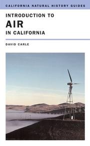
What is air? Why is the sky blue? Why do people react favorably to mountain or sea air? How does desert air differ from the air of California's Central Valley? How is air pollution affecting plants and animals? This book is a unique guide to the air we breathe in California. More than a natural history guide, it approaches this fascinating topic by recognizing the overwhelming role played by humans in the story of California's air. In a highly engaging style, David Carle explains daily weather patterns, seasonal climate, characteristic winds, and sky phenomena. He explores air as the gases in our atmosphere, but also considers the aspects of air that influence all of our senses-its taste, smell, feel, and look. The guide discusses California's history of air quality management, air pollution and its effect on humans and the environment, and the technological and individual measures needed to address these challenges. The book also functions as a handbook for more environmentally conscious living by providing information on alternative energy sources for consumers and tips for cleaner running cars. * Features 80 color photographs, 23 figures, 18 maps* Covers regional differences of topography, weather, and the character of the air in California's fifteen designated air basins* Includes a field guide to the sky, explaining color and light, clouds and wind, and the nature of flight* Addresses issues surrounding global climate change in CaliforniaA book in the Californians and Their Environment subseries, dedicated to understanding human influences on the state's ecology and natural resources
Air quality --- Air --- Atmosphere. --- Atmospheric science --- Quality of air --- Environmental quality --- Pollution --- Quality --- air basins. --- air feel. --- air pollution. --- air quality management. --- air quality. --- air smell. --- air taste. --- alternative energy sources. --- atmospheric gases. --- breathable air. --- california history. --- california. --- central valley. --- cleaner cars. --- climate change. --- color photographs. --- consumer society. --- environmental impact. --- human impact. --- natural history guide. --- natural history. --- natural resources. --- nonfiction. --- seasonal climate. --- sky phenomena. --- sustainability. --- topography. --- weather patterns. --- wind patterns.
Book
ISBN: 022629742X 9780226297422 9780226297255 9780226297392 Year: 2015 Publisher: Chicago : University of Chicago Press,
Abstract | Keywords | Export | Availability | Bookmark
Loading...Choose an application
- Reference Manager
- EndNote
- RefWorks (Direct export to RefWorks)
City and regional planners talk constantly about the things of the world-from highway interchanges and retention ponds to zoning documents and conference rooms-yet most seem to have a poor understanding of the materiality of the world in which they're immersed. Too often planners treat built forms, weather patterns, plants, animals, or regulatory technologies as passively awaiting commands rather than actively involved in the workings of cities and regions. In the ambitious and provocative Planning Matter, Robert A. Beauregard sets out to offer a new materialist perspective on planning practice that reveals the many ways in which the nonhuman things of the world mediate what planners say and do. Drawing on actor-network theory and science and technology studies, Beauregard lays out a framework that acknowledges the inevitable insufficiency of our representations of reality while also engaging more holistically with the world in all of its diversity-including human and nonhuman actors alike.
City planning. --- City planning --- Cities and towns --- Civic planning --- Land use, Urban --- Model cities --- Redevelopment, Urban --- Slum clearance --- Town planning --- Urban design --- Urban development --- Urban planning --- Land use --- Planning --- Art, Municipal --- Civic improvement --- Regional planning --- Urban policy --- Urban renewal --- Government policy --- Management --- architectural criticism, social philosophy, urban planning, land use, city planners, highway interchanges, retention ponds, zoning documents, conference rooms, materiality, weather patterns, plants and animals, regulatory technologies, new materialist perspective, nonhuman things, actor-network theory, science, technology studies, human world, perception, sociology, civic duty, thought experiment, preservation.
Book
Year: 2021 Publisher: Basel, Switzerland MDPI - Multidisciplinary Digital Publishing Institute
Abstract | Keywords | Export | Availability | Bookmark
Loading...Choose an application
- Reference Manager
- EndNote
- RefWorks (Direct export to RefWorks)
Globally, fire regimes are being altered by changing climatic conditions and land use changes. This has the potential to drive species extinctions and cause ecosystem state changes, with a range of consequences for ecosystem services. Accurate prediction of the risk of forest fires over short timescales (weeks or months) is required for land managers to target suppression resources in order to protect people, property, and infrastructure, as well as fire-sensitive ecosystems. Over longer timescales, prediction of changes in forest fire regimes is required to model the effect of wildfires on the terrestrial carbon cycle and subsequent feedbacks into the climate system.This was the motivation to publish this book, which is focused on quantifying and modelling the risk factors of forest fires. More specifically, the chapters in this book address four topics: (i) the use of fire danger metrics and other approaches to understand variation in wildfire activity; (ii) understanding changes in the flammability of live fuel; (iii) modeling dead fuel moisture content; and (iv) estimations of emission factors.The book will be of broad relevance to scientists and managers working with fire in different forest ecosystems globally.
fire danger rating --- fire management --- fire regime --- fire size --- fire weather --- Portugal --- critical LFMC threshold --- forest/grassland fire --- radiative transfer model --- remote sensing --- southwest China --- acid rain --- aerosol --- biomass burning --- forest fire --- PM2.5 --- direct estimation --- meteorological factor regression --- moisture content --- time lag --- forest fire driving factors --- forest fire occurrence --- random forest --- forest fire management --- China --- Cupressus sempervirens --- fire risk --- fuels --- fuel moisture content --- mass loss calorimeter --- Seiridium cardinale --- vulnerability to wildfires --- disease --- alien pathogen --- allochthonous species --- introduced fungus --- drying tests --- humidity diffusion coefficients --- wildfire --- prescribed burning --- modeling --- drought --- flammability --- fuel moisture --- leaf water potential --- plant traits --- climate change --- MNI --- fire season --- fire behavior --- crown fire --- fire modeling --- senescence --- foliar moisture content --- canopy bulk density --- fire danger --- fire weather patterns --- RCP --- FWI system --- SSR --- occurrence of forest fire --- machine learning --- variable importance --- prediction accuracy --- epicormic resprouter --- eucalyptus --- fire severity --- flammability feedbacks --- temperate forest --- n/a
Book
Year: 2021 Publisher: Basel, Switzerland MDPI - Multidisciplinary Digital Publishing Institute
Abstract | Keywords | Export | Availability | Bookmark
Loading...Choose an application
- Reference Manager
- EndNote
- RefWorks (Direct export to RefWorks)
Globally, fire regimes are being altered by changing climatic conditions and land use changes. This has the potential to drive species extinctions and cause ecosystem state changes, with a range of consequences for ecosystem services. Accurate prediction of the risk of forest fires over short timescales (weeks or months) is required for land managers to target suppression resources in order to protect people, property, and infrastructure, as well as fire-sensitive ecosystems. Over longer timescales, prediction of changes in forest fire regimes is required to model the effect of wildfires on the terrestrial carbon cycle and subsequent feedbacks into the climate system.This was the motivation to publish this book, which is focused on quantifying and modelling the risk factors of forest fires. More specifically, the chapters in this book address four topics: (i) the use of fire danger metrics and other approaches to understand variation in wildfire activity; (ii) understanding changes in the flammability of live fuel; (iii) modeling dead fuel moisture content; and (iv) estimations of emission factors.The book will be of broad relevance to scientists and managers working with fire in different forest ecosystems globally.
Research & information: general --- Biology, life sciences --- Forestry & related industries --- fire danger rating --- fire management --- fire regime --- fire size --- fire weather --- Portugal --- critical LFMC threshold --- forest/grassland fire --- radiative transfer model --- remote sensing --- southwest China --- acid rain --- aerosol --- biomass burning --- forest fire --- PM2.5 --- direct estimation --- meteorological factor regression --- moisture content --- time lag --- forest fire driving factors --- forest fire occurrence --- random forest --- forest fire management --- China --- Cupressus sempervirens --- fire risk --- fuels --- fuel moisture content --- mass loss calorimeter --- Seiridium cardinale --- vulnerability to wildfires --- disease --- alien pathogen --- allochthonous species --- introduced fungus --- drying tests --- humidity diffusion coefficients --- wildfire --- prescribed burning --- modeling --- drought --- flammability --- fuel moisture --- leaf water potential --- plant traits --- climate change --- MNI --- fire season --- fire behavior --- crown fire --- fire modeling --- senescence --- foliar moisture content --- canopy bulk density --- fire danger --- fire weather patterns --- RCP --- FWI system --- SSR --- occurrence of forest fire --- machine learning --- variable importance --- prediction accuracy --- epicormic resprouter --- eucalyptus --- fire severity --- flammability feedbacks --- temperate forest
Book
ISBN: 1280994487 9786613766090 0226740706 9780226740706 9780226740683 0226740684 9781280994487 6613766097 Year: 2012 Publisher: Chicago ; London : University of Chicago Press,
Abstract | Keywords | Export | Availability | Bookmark
Loading...Choose an application
- Reference Manager
- EndNote
- RefWorks (Direct export to RefWorks)
In the nineteenth century, Americans began to use maps in radically new ways. For the first time, medical men mapped diseases to understand and prevent epidemics, natural scientists mapped climate and rainfall to uncover weather patterns, educators mapped the past to foster national loyalty among students, and Northerners mapped slavery to assess the power of the South. After the Civil War, federal agencies embraced statistical and thematic mapping in order to profile the ethnic, racial, economic, moral, and physical attributes of a reunified nation. By the end of the century, Congress had authorized a national archive of maps, an explicit recognition that old maps were not relics to be discarded but unique records of the nation's past. All of these experiments involved the realization that maps were not just illustrations of data, but visual tools that were uniquely equipped to convey complex ideas and information. In Mapping the Nation, Susan Schulten charts how maps of epidemic disease, slavery, census statistics, the environment, and the past demonstrated the analytical potential of cartography, and in the process transformed the very meaning of a map. Today, statistical and thematic maps are so ubiquitous that we take for granted that data will be arranged cartographically. Whether for urban planning, public health, marketing, or political strategy, maps have become everyday tools of social organization, governance, and economics. The world we inhabit-saturated with maps and graphic information-grew out of this sea change in spatial thought and representation in the nineteenth century, when Americans learned to see themselves and their nation in new dimensions.
Thematic maps --- Cartography --- Cartography, Primitive --- Chartography --- Map-making --- Mapmaking --- Mapping (Cartography) --- Mathematical geography --- Surveying --- Map projection --- Maps --- Single-topic maps --- Special-purpose maps --- History --- United States --- ABŞ --- ABSh --- Ameerika Ühendriigid --- America (Republic) --- Amerika Birlăshmish Shtatlary --- Amerika Birlăşmi Ştatları --- Amerika Birlăşmiş Ştatları --- Amerika ka Kelenyalen Jamanaw --- Amerika Qūrama Shtattary --- Amerika Qŭshma Shtatlari --- Amerika Qushma Shtattary --- Amerika (Republic) --- Amerikai Egyesült Államok --- Amerikanʹ Veĭtʹsėndi︠a︡vks Shtattnė --- Amerikări Pĕrleshu̇llĕ Shtatsem --- Amerikas Forenede Stater --- Amerikayi Miatsʻyal Nahangner --- Ameriketako Estatu Batuak --- Amirika Carékat --- AQSh --- Ar. ha-B. --- Arhab --- Artsot ha-Berit --- Artzois Ha'bris --- Bí-kok --- Ē.P.A. --- EE.UU. --- Egyesült Államok --- ĒPA --- Estados Unidos --- Estados Unidos da América do Norte --- Estados Unidos de América --- Estaos Xuníos --- Estaos Xuníos d'América --- Estatos Unitos --- Estatos Unitos d'America --- Estats Units d'Amèrica --- Ètats-Unis d'Amèrica --- États-Unis d'Amérique --- Fareyniḳṭe Shṭaṭn --- Feriene Steaten --- Feriene Steaten fan Amearika --- Forente stater --- FS --- Hēnomenai Politeiai Amerikēs --- Hēnōmenes Politeies tēs Amerikēs --- Hiwsisayin Amerikayi Miatsʻeal Tērutʻiwnkʻ --- Istadus Unidus --- Jungtinės Amerikos valstybės --- Mei guo --- Mei-kuo --- Meiguo --- Mî-koet --- Miatsʻyal Nahangner --- Miguk --- Na Stàitean Aonaichte --- NSA --- S.U.A. --- SAD --- Saharat ʻAmērikā --- SASht --- Severo-Amerikanskie Shtaty --- Severo-Amerikanskie Soedinennye Shtaty --- Si︠e︡vero-Amerikanskīe Soedinennye Shtaty --- Sjedinjene Američke Države --- Soedinennye Shtaty Ameriki --- Soedinennye Shtaty Severnoĭ Ameriki --- Soedinennye Shtaty Si︠e︡vernoĭ Ameriki --- Spojené staty americké --- SShA --- Stadoù-Unanet Amerika --- Stáit Aontaithe Mheiriceá --- Stany Zjednoczone --- Stati Uniti --- Stati Uniti d'America --- Stâts Unîts --- Stâts Unîts di Americhe --- Steatyn Unnaneysit --- Steatyn Unnaneysit America --- SUA (Stati Uniti d'America) --- Sŭedineni amerikanski shtati --- Sŭedinenite shtati --- Tetã peteĩ reko Amérikagua --- U.S. --- U.S.A. --- United States of America --- Unol Daleithiau --- Unol Daleithiau America --- Unuiĝintaj Ŝtatoj de Ameriko --- US --- USA --- Usono --- Vaeinigte Staatn --- Vaeinigte Staatn vo Amerika --- Vereinigte Staaten --- Vereinigte Staaten von Amerika --- Verenigde State van Amerika --- Verenigde Staten --- VS --- VSA --- Wááshindoon Bikéyah Ałhidadiidzooígíí --- Wilāyāt al-Muttaḥidah --- Wilāyāt al-Muttaḥidah al-Amirīkīyah --- Wilāyāt al-Muttaḥidah al-Amrīkīyah --- Yhdysvallat --- Yunaeted Stet --- Yunaeted Stet blong Amerika --- ZDA --- Združene države Amerike --- Zʹi︠e︡dnani Derz︠h︡avy Ameryky --- Zjadnośone staty Ameriki --- Zluchanyi︠a︡ Shtaty Ameryki --- Zlucheni Derz︠h︡avy --- ZSA --- Η.Π.Α. --- Ηνωμένες Πολιτείες της Αμερικής --- Америка (Republic) --- Американь Вейтьсэндявкс Штаттнэ --- Америкӑри Пӗрлешӳллӗ Штатсем --- САЩ --- Съединените щати --- Злучаныя Штаты Амерыкі --- ولايات المتحدة --- ولايات المتّحدة الأمريكيّة --- ولايات المتحدة الامريكية --- 미국 --- Spojené obce severoamerické --- États-Unis --- É.-U. --- ÉU --- maps, cartography, history, epidemics, climate, rainfall, weather patterns, tracking, disease, slavery, civil war, ethnicity, race, archive, congress, census, environmentalism, economics, governance, government, politics, political science, social organization, marketing, public health, urban planning, nonfiction, expansion, visual culture, statistics, demographics, 19th century.
| Listing 1 - 7 of 7 |
Sort by
|