
 Search
 Feedback
 About
About Help
Help News
News
| Listing 1 - 9 of 9 |
Sort by
|
Map
Year: 1834 Publisher: [Lieu de publication inconnu]: [éditeur inconnu],
Abstract | Keywords | Export | Availability | Bookmark
 Loading...
Choose an application
- Reference Manager
- EndNote
- RefWorks (Direct export to RefWorks)
Map
Abstract | Keywords | Export | Availability | Bookmark
Loading...Choose an application
- Reference Manager
- EndNote
- RefWorks (Direct export to RefWorks)
Belgium --- Transports --- Cartes
Map
ISBN: 9780415837088 Year: 2018 Publisher: Abingdon : Informa Law,
Abstract | Keywords | Export | Availability | Bookmark
Loading...Choose an application
- Reference Manager
- EndNote
- RefWorks (Direct export to RefWorks)
Shipping --- Harbors --- Ports --- Transports maritimes
Map
Year: 1976 Publisher: Bruxelles: Académie royale des sciences d'outre-mer,
Abstract | Keywords | Export | Availability | Bookmark
Loading...Choose an application
- Reference Manager
- EndNote
- RefWorks (Direct export to RefWorks)
ISBN: 9780143112655 0143112651 Year: 2007 Publisher: New York : Penguin Books,
Abstract | Keywords | Export | Availability | Bookmark
Loading...Choose an application
- Reference Manager
- EndNote
- RefWorks (Direct export to RefWorks)
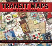
Transit Maps of the World est la première et unique collection complète de cartes historiques et actuelles de chaque système de transit rapide sur terre. Dans un graphisme précis et coloré, Mark Ovenden retrace l'histoire cartographique du transport en commun, y compris des cartes, des diagrammes et des photographies rares et historiques, certains disponibles pour la première fois depuis leur publication originale.
Subways --- Local transit --- Railroads --- Métros --- Transports publics --- Transports ferroviaires --- History --- Maps --- Maps. --- Histoire --- Atlas --- Transport en commun --- Cartographie --- Graphisme --- Métros
Multi
ISBN: 9782080296252 2080296256 Year: 2023 Publisher: Paris : Editions Autrement,
Abstract | Keywords | Export | Availability | Bookmark
Loading...Choose an application
- Reference Manager
- EndNote
- RefWorks (Direct export to RefWorks)
Map
ISBN: 1854142887 Year: 2005 Publisher: Harrow Middlesex : Published by Capital Transport Publishing,
Abstract | Keywords | Export | Availability | Bookmark
Loading...Choose an application
- Reference Manager
- EndNote
- RefWorks (Direct export to RefWorks)
Subways --- Local transit --- Visual communication --- Métros --- Transports publics --- Communication visuelle --- Maps. --- Maps --- Atlas --- Atlas
Map
ISBN: 9780670022656 0670022659 Year: 2011 Publisher: New York, NY : Viking,
Abstract | Keywords | Export | Availability | Bookmark
Loading...Choose an application
- Reference Manager
- EndNote
- RefWorks (Direct export to RefWorks)
A collection of international railway maps and posters features a chronological timeline from the Liverpool and Manchester Railway of 1830 to the proposed 2020 high-speed networks of China in an atlas representing more than one hundred countries.
Railroads --- Railroads --- Transports ferroviaires --- Chemins de fer --- History --- Maps --- Maps --- Histoire --- Atlas --- Atlas
Map
Abstract | Keywords | Export | Availability | Bookmark
Loading...Choose an application
- Reference Manager
- EndNote
- RefWorks (Direct export to RefWorks)
Belgium --- Cartes --- Early works to 2000 --- Belgium --- Transports --- Cartes --- World's Fair (1913: Gent) --- Cartes
| Listing 1 - 9 of 9 |
Sort by
|