
 Search
 Feedback
 About UniCat
  Help
Help News
News
| Listing 1 - 10 of 23 | << page >> |
Sort by
|
Book
ISBN: 1283636581 0826350089 9780826350084 9780826350060 0826350062 Year: 2010 Publisher: Albuquerque University of New Mexico Press
Abstract | Keywords | Export | Availability | Bookmark
 Loading...
Choose an application
- Reference Manager
- EndNote
- RefWorks (Direct export to RefWorks)
Chichimecs --- Chichimec Indians --- Indians of Mexico --- Social life and customs --- Origin --- History --- Mapa de Cuauhtinchan núm. 2 --- Mapa de Cuauhtinchan número 2 --- Mapa de Cuauhtinchan número dos --- Mapa de Cuauhtinchan núm. dos --- MC2 --- Mapa de la ruta Chicomoztoc-Cuauhtinchan --- Cuautinchán (Mexico) --- Quauhtinchan, Mexico --- Quauhtinchan (Mexico) --- Cuauhtinchan (Mexico) --- Mapa de Cuauhtinchan num. 2. --- Cuautinchan (Mexico)
Book
ISBN: 0292793057 Year: 2010 Publisher: Austin : University of Texas Press,
Abstract | Keywords | Export | Availability | Bookmark
Loading...Choose an application
- Reference Manager
- EndNote
- RefWorks (Direct export to RefWorks)
Around 1542, descendants of the Aztec rulers of Mexico created accounts of the pre-Hispanic history of the city of Tetzcoco, Mexico, one of the imperial capitals of the Aztec Empire. Painted in iconic script ("picture writing"), the Codex Xolotl, the Quinatzin Map, and the Tlohtzin Map appear to retain and emphasize both pre-Hispanic content and also pre-Hispanic form, despite being produced almost a generation after the Aztecs surrendered to Hernán Cortés in 1521. Yet, as this pioneering study makes plain, the reality is far more complex. Eduardo de J. Douglas offers a detailed critical analysis and historical contextualization of the manuscripts to argue that colonial economic, political, and social concerns affected both the content of the three Tetzcocan pictorial histories and their archaizing pictorial form. As documents composed by indigenous people to assert their standing as legitimate heirs of the Aztec rulers as well as loyal subjects of the Spanish Crown and good Catholics, the Tetzcocan manuscripts qualify as subtle yet shrewd negotiations between indigenous and Spanish systems of signification and between indigenous and Spanish concepts of real property and political rights. By reading the Tetzcocan manuscripts as calculated responses to the changes and challenges posed by Spanish colonization and Christian evangelization, Douglas's study significantly contributes to and expands upon the scholarship on central Mexican manuscript painting and recent critical investigations of art and political ideology in colonial Latin America.
Manuscripts, Nahuatl --- Aztec art --- Aztecs --- Palaces --- History --- Nezahualcóyotl, --- Homes and haunts --- Codex Xolotl. --- Mapa Quinatzin. --- Mapa Tlohtzin. --- Texcoco de Mora (Mexico) --- Texcoco de Mora (Mexico) --- History --- Antiquities.
Book
ISBN: 9780292793057 0292793057 9780292721685 0292721684 Year: 2010 Publisher: Austin University of Texas Press
Abstract | Keywords | Export | Availability | Bookmark
Loading...Choose an application
- Reference Manager
- EndNote
- RefWorks (Direct export to RefWorks)
Around 1542, descendants of the Aztec rulers of Mexico created accounts of the pre-Hispanic history of the city of Tetzcoco, Mexico, one of the imperial capitals of the Aztec Empire. Painted in iconic script ("picture writing"), the Codex Xolotl, the Quinatzin Map, and the Tlohtzin Map appear to retain and emphasize both pre-Hispanic content and also pre-Hispanic form, despite being produced almost a generation after the Aztecs surrendered to Hernán Cortés in 1521. Yet, as this pioneering study makes plain, the reality is far more complex. Eduardo de J. Douglas offers a detailed critical analysis and historical contextualization of the manuscripts to argue that colonial economic, political, and social concerns affected both the content of the three Tetzcocan pictorial histories and their archaizing pictorial form. As documents composed by indigenous people to assert their standing as legitimate heirs of the Aztec rulers as well as loyal subjects of the Spanish Crown and good Catholics, the Tetzcocan manuscripts qualify as subtle yet shrewd negotiations between indigenous and Spanish systems of signification and between indigenous and Spanish concepts of real property and political rights. By reading the Tetzcocan manuscripts as calculated responses to the changes and challenges posed by Spanish colonization and Christian evangelization, Douglas's study significantly contributes to and expands upon the scholarship on central Mexican manuscript painting and recent critical investigations of art and political ideology in colonial Latin America.
Manuscripts, Nahuatl --- Aztec art --- Aztecs --- Palaces --- History --- Nezahualcóyotl, --- Homes and haunts --- Codex Xolotl. --- Mapa Quinatzin. --- Mapa Tlohtzin. --- Texcoco de Mora (Mexico) --- Antiquities. --- Nezahualcoyotl,
Book
ISBN: 9707014229 Year: 2004 Publisher: México : Comisión Nacional de los Derechos Humanos México : CIESAS : Miguel Angel Porrúa,
Abstract | Keywords | Export | Availability | Bookmark
Loading...Choose an application
- Reference Manager
- EndNote
- RefWorks (Direct export to RefWorks)
Chichimecs --- Chichimec (Indiens) --- Wars. --- Politics and government. --- Social life and customs. --- Guerres --- Politique et gouvernement --- Moeurs et coutumes --- Mapa Quinatzin.
Book
ISBN: 9788499250625 Year: 2011 Publisher: Valencia Editorial cultural y espiritual popular S.L.
Abstract | Keywords | Export | Availability | Bookmark
Loading...Choose an application
- Reference Manager
- EndNote
- RefWorks (Direct export to RefWorks)
las sectas --- mapa de la heterodoxia --- Espana --- Iberomaerica --- ser captado por una secta --- salirse de una secta --- los adeptos --- masoneria --- nueva era --- neopaganismo --- el potencial humano --- organizaciones antisectas --- lavado de cerebro --- control mental
Multi
ISBN: 9783836538039 3836538032 Year: 2016 Publisher: Köln: Taschen,
Abstract | Keywords | Export | Availability | Bookmark
Loading...Choose an application
- Reference Manager
- EndNote
- RefWorks (Direct export to RefWorks)
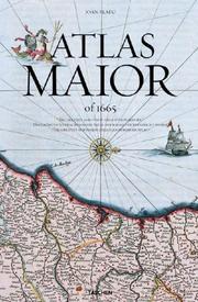
Les superlatifs manquent pour qualifier l’Atlas Maior de Joan Blaeu, l’un des plus grands trésors de toute l’histoire de la cartographie. L’édition originale en latin, achevée en 1565, fut le livre le plus grand et le plus cher jamais publié au cours du XVIIe siècle. Ses 594 cartes rassemblées en 11 volumes parcouraient l’Arctique, l'Afrique, l’Asie, l’Europe et l’Amérique. Son envergure et son ambition lui conféraient une place si essentielle dans l’histoire néerlandaise que l’ouvrage fait partie du Canon historique des Pays-Bas, la liste officielle des 50 personnalités, œuvres et événements qui résument la formation des Pays-Bas. La reproduction de cet atlas de grande valeur, réalisée avec soin par TASCHEN, permet aux lecteurs d’aujourd’hui d’avoir entre les mains ce chef-d’œuvre du baroque si précieux. À une époque où les cartes sont numériques et où le réseau est mondial, l’ouvrage célèbre l’éternelle beauté d’une édition imprimée et retrace le miracle de l’âge des grandes découvertes, période durant laquelle Amsterdam, ville d’origine de Blaeu, était au centre du commerce international et un point de passage des explorateurs. Conforme à la qualité de reproduction habituelle des ouvrages de TASCHEN, cette édition a été réalisée à partir d’un exemplaire complet de l’Atlas Maior, en couleurs et rehaussé d’or, conservé à la Bibliothèque nationale d’Autriche à Vienne, qui restitue les moindres détails et garantit une qualité irréprochable. Peter van der Krogt, professeur à l’université d’Amsterdam, aborde en introduction la signification ainsi que l’importance historique et culturelle de l’atlas tout en apportant pour chaque carte des explications détaillées qui révèlent la portée et l’ambition du chef-d’œuvre de Blaeu. Renfermant autant une œuvre d’art qu’une prouesse cartographique, ce livre est inséré dans un coffret qui se transforme facilement en lutrin.
Cartography --- Atlases, Dutch --- History --- Atlas --- atlants --- atlante --- άτλας --- atlas --- atlasz --- kartasto --- атлас --- atlasas --- γεωγραφικός χάρτης --- zemljopisni atlas --- mapa --- karte --- globus --- landkort --- светски атлас --- тематски атлас --- carta geográfica --- geografisk karta --- földrajzi atlasz --- carte géographique --- atlante storico --- tematický atlas --- zeměpisný atlas --- maakaart --- atlante linguistico --- zemljovid --- map --- kartografické dokumenty --- maantieteellinen kartta --- Landkarte --- carta geografica --- hartă --- víceoborový atlas --- глобус --- jednooborový atlas --- žemėlapis --- hartë --- geografische kaart --- atlante geografico --- soubor map --- Cartography - History --- Atlases, Dutch - Early works to 1800 - Facsimiles
Book
ISBN: 9782035887917 2035887917 Year: 2013 Publisher: Paris: Larousse,
Abstract | Keywords | Export | Availability | Bookmark
Loading...Choose an application
- Reference Manager
- EndNote
- RefWorks (Direct export to RefWorks)
Geopolitics --- Atlas --- Géopolitique --- BPB1307 --- atlants --- atlante --- άτλας --- atlas --- atlasz --- kartasto --- атлас --- atlasas --- γεωγραφικός χάρτης --- zemljopisni atlas --- mapa --- karte --- globus --- landkort --- светски атлас --- тематски атлас --- carta geográfica --- geografisk karta --- földrajzi atlasz --- carte géographique --- atlante storico --- tematický atlas --- zeměpisný atlas --- maakaart --- atlante linguistico --- zemljovid --- map --- kartografické dokumenty --- maantieteellinen kartta --- Landkarte --- carta geografica --- hartă --- víceoborový atlas --- глобус --- jednooborový atlas --- žemėlapis --- hartë --- geografische kaart --- atlante geografico --- soubor map --- Geopolitiek --- Geopolitics - Maps
Multi

ISBN: 9782710808978 Year: 2008 Publisher: Paris : Technip,
Abstract | Keywords | Export | Availability | Bookmark
Loading...Choose an application
- Reference Manager
- EndNote
- RefWorks (Direct export to RefWorks)
Geopolitics --- Law of the sea --- Géopolitique --- Droit de la mer --- Atlases --- Atlas --- BPB0903 --- 347.79 --- Zeerecht--(volkenrechtelijk z {341.225}; verkeer te water z.o.{656.6}) --- 347.79 Zeerecht--(volkenrechtelijk z {341.225}; verkeer te water z.o.{656.6}) --- Géopolitique --- atlants --- atlante --- άτλας --- atlas --- atlasz --- kartasto --- атлас --- atlasas --- γεωγραφικός χάρτης --- zemljopisni atlas --- mapa --- karte --- globus --- landkort --- светски атлас --- тематски атлас --- carta geográfica --- geografisk karta --- földrajzi atlasz --- carte géographique --- atlante storico --- tematický atlas --- zeměpisný atlas --- maakaart --- atlante linguistico --- zemljovid --- map --- kartografické dokumenty --- maantieteellinen kartta --- Landkarte --- carta geografica --- hartă --- víceoborový atlas --- глобус --- jednooborový atlas --- žemėlapis --- hartë --- geografische kaart --- atlante geografico --- soubor map
ISBN: 3822831255 9783822831250 Year: 2005 Publisher: Köln: Taschen,
Abstract | Keywords | Export | Availability | Bookmark
Loading...Choose an application
- Reference Manager
- EndNote
- RefWorks (Direct export to RefWorks)
cartography [discipline] --- Book history --- Geodesy. Cartography --- cartografie --- Blaeu, Joan I --- anno 1600-1699 --- Cartography --- Atlases, Dutch --- History --- History. --- 912 "16" --- 912 <100> --- Atlas --- Cartografie. Kaarten. Plattegronden. Atlassen--17e eeuw. Periode 1600-1699 --- Cartografie. Kaarten. Plattegronden. Atlassen--Wereld. Internationaal. Alle landen gezamenlijk --- atlants --- atlante --- άτλας --- atlas --- atlasz --- kartasto --- атлас --- atlasas --- γεωγραφικός χάρτης --- zemljopisni atlas --- mapa --- karte --- globus --- landkort --- светски атлас --- тематски атлас --- carta geográfica --- geografisk karta --- földrajzi atlasz --- carte géographique --- atlante storico --- tematický atlas --- zeměpisný atlas --- maakaart --- atlante linguistico --- zemljovid --- map --- kartografické dokumenty --- maantieteellinen kartta --- Landkarte --- carta geografica --- hartă --- víceoborový atlas --- глобус --- jednooborový atlas --- žemėlapis --- hartë --- geografische kaart --- atlante geografico --- soubor map --- Cartography - History --- Atlases, Dutch - Early works to 1800 - Facsimiles --- Cartography - History. --- Cartes anciennes --- Österreichische nationalbibliothek --- Atlas neerlandais --- Geographie --- Atlas geographique --- Blaeu (joan), 1598-1673 --- Ouvrages avant 1800 --- Fac-similes --- Manuscrits. atlas maior
Book
ISBN: 029279407X 0292718314 Year: 2008 Publisher: University of Texas Press
Abstract | Keywords | Export | Availability | Bookmark
Loading...Choose an application
- Reference Manager
- EndNote
- RefWorks (Direct export to RefWorks)
Created in Tepechpan, a relatively minor Aztec city in Central Mexico, the Tira de Tepechpan records important events in the city's history from 1298 through 1596. Most of the history is presented pictographically. A line of indigenous year signs runs the length of the Tira, with images above the line depicting events in Tepechpan and images below the line recording events at Tenochtitlan, capital of the Aztec empire and later the seat of Spanish rule. Written annotations amplify some of the images. In this volume, which includes color plates of the entire Tira, Lori Boornazian Diel investigates the motives behind the creation and modification of the Tira in the second half of the sixteenth century. She identifies the Tira's different contributors and reconciles their various histories by asking why these painters and annotators, working at different times, recorded the events that they did. Comparing the Tira to other painted histories from Central Mexico, Diel demonstrates that the main goal of the Tira was to establish the antiquity, autonomy, and prestige of Tepechpan among the Central Mexican city-states that vied for power and status in the preconquest and colonial worlds. Offering the unique point of view of a minor city with grand ambitions, this study of the Tira reveals imperial strategy from the grassroots up, showing how a subject city negotiated its position under Aztec and Spanish control.
Aztecs --- Aztec art --- History --- First contact with Europeans. --- Tira de Tepechpan. --- Tepexpan (Mexico) --- Mexico --- Spain --- Colonies --- Administration. --- First contact of aboriginal peoples with Westerners --- Art, Aztec --- Art, Mexican --- Aztec Indians --- Azteca Indians --- Aztecan Indians --- Mexica Indians --- Tenocha Indians --- Indians of Mexico --- Nahuas --- Art --- Mapa de Tepechpan --- Mappe de Tepechpan --- Espagne --- Espainiako Erresuma --- España --- Espanha --- Espanja --- Espanya --- Estado Español --- Hispania --- Hiszpania --- Isupania --- Kingdom of Spain --- Regne d'Espanya --- Reiaume d'Espanha --- Reino de España --- Reino d'Espanya --- Reinu d'España --- Sefarad --- Sepharad --- Shpanie --- Shpanye --- Spanien --- Spanish State --- Supein --- イスパニア --- スペイン --- Tepechpan (Mexico) --- Santa Cruz Tepexpan (Mexico) --- Santa Cruz (Mexico) --- First contact (Anthropology) --- First contact with Europeans --- First contact with other peoples.
| Listing 1 - 10 of 23 | << page >> |
Sort by
|