
 Search
 Feedback
 About UniCat
  Help
Help News
News
| Listing 1 - 10 of 11 | << page >> |
Sort by
|
Book
Year: 1956 Publisher: [Washington] : U.S. Dept. of the army,
Abstract | Keywords | Export | Availability | Bookmark
 Loading...
Choose an application
- Reference Manager
- EndNote
- RefWorks (Direct export to RefWorks)
Geografie --- Maps, Military. --- Cartografie --- Kaartgebruik.
Map
Year: 1943 Publisher: [London?]: MI9,
Abstract | Keywords | Export | Availability | Bookmark
Loading...Choose an application
- Reference Manager
- EndNote
- RefWorks (Direct export to RefWorks)
Double sided map printed on fabric, specifically for evasion and escape purposes, by MI9, a military intelligence section in the War Office
Coasts --- Maps, Military --- Scandinavia --- Murmansk Region (Russia)
Map
Year: 1943 Publisher: [London?]: [War office. MI9],
Abstract | Keywords | Export | Availability | Bookmark
Loading...Choose an application
- Reference Manager
- EndNote
- RefWorks (Direct export to RefWorks)
Double sided map printed on fabric, specifically for evasion and escape purposes, by MI9, a military intelligence section in the War Office. Shows towns, roads with distances, railways, mountain passes, international frontiers, Franco-Spanish frontier, and the northern limit of forbidden zone. Include legends
Maps, Military --- Europe, Western --- Pyrenees --- Germany --- Switzerland
Book
Year: 1942 Publisher: Berlin : Mittler,
Abstract | Keywords | Export | Availability | Bookmark
Loading...Choose an application
- Reference Manager
- EndNote
- RefWorks (Direct export to RefWorks)
Geografie --- Maps, Military. --- Military topography. --- Cartografie --- Algemeen.
Book
Year: 1924 Publisher: New York (N.Y.) : American geographical society,
Abstract | Keywords | Export | Availability | Bookmark
Loading...Choose an application
- Reference Manager
- EndNote
- RefWorks (Direct export to RefWorks)
Cartography --- Maps, Military. --- History. --- American geographical society of New York.
Map
Year: 1964 Publisher: [Lieu de publication inconnu]: Armeekartenstelle,
Abstract | Keywords | Export | Availability | Bookmark
Loading...Choose an application
- Reference Manager
- EndNote
- RefWorks (Direct export to RefWorks)
Grèce. Militaire. 1:100 000e. 1943-1944 --- Military Topography --- Maps, Military --- Greece
Book
ISBN: 9780226755243 022675524X 9780712353137 0712353135 Year: 2020 Publisher: Chicago The University of Chicago Press
Abstract | Keywords | Export | Availability | Bookmark
Loading...Choose an application
- Reference Manager
- EndNote
- RefWorks (Direct export to RefWorks)
Assembled by the same team responsible for A History of America in 100 Maps by Susan Schulten, this book offers a selection of 100 maps, all presented in full color, that shaped the course of World War II. Alongside the maps, historian Jeremy Black offers context and explanations drawing on his long career thinking about war and maps. World War II was a uniquely difficult war to map: it was fought across an unprecedented geographical range, through the air as well as by land and sea, and at a faster tempo than any previous conflict. Creating maps for the military to use as tools, as well as for governments and others to use in spreading their messages about the war, presented new challenges to mapmakers. But the development of new technologies such as aerial photography and all-weather instrument flying aided their efforts, and the scale of map production during the war was astonishing. The maps in this book are drawn from the British Library's collections as well as other sources across the world and organized thematically. In addition to military operations, tactics, and strategy on all sides, the maps illustrate the geopolitical context for war as well as reporting and propaganda efforts by the Allies and the Axis countries during and after the war.
World War, 1939-1945 --- Military maps --- Cartography --- Cartography, Primitive --- Chartography --- Map-making --- Mapmaking --- Mapping (Cartography) --- Mathematical geography --- Surveying --- Map projection --- Maps --- Maps, Military --- Military topography --- History --- Political aspects
Book
ISBN: 3319252445 3319252429 Year: 2016 Publisher: Cham : Springer International Publishing : Imprint: Springer,
Abstract | Keywords | Export | Availability | Bookmark
Loading...Choose an application
- Reference Manager
- EndNote
- RefWorks (Direct export to RefWorks)
This volume gathers 19 papers first presented at the 5th International Symposium of the ICA Commission on the History of Cartography, which took place at the University of Ghent, Belgium on 2-5 December 2014. The overall conference theme was 'Cartography in Times of War and Peace', but preference was given to papers dealing with the military cartography of the First World War (1914-1918). The papers are classified by period and regional sub-theme, i.e. Military Cartography from the 18th to the 20th century; WW I Cartography in Belgium, Central Europe, etc.
Military topography --- Military maps --- Maps, Military --- Maps --- Military surveying --- Surveying, Military --- Topography, Military --- Cartography --- Military geography --- Topographical surveying --- Military reconnaissance --- Geographical information systems. --- Geographical Information Systems/Cartography. --- Geographical information systems --- GIS (Information systems) --- Information storage and retrieval systems --- Geography
ISBN: 0292706596 0292796773 Year: 2005 Publisher: Austin University of texas press
Abstract | Keywords | Export | Availability | Bookmark
Loading...Choose an application
- Reference Manager
- EndNote
- RefWorks (Direct export to RefWorks)
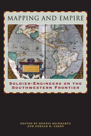
From the sixteenth through the mid-nineteenth centuries, Spain, then Mexico, and finally the United States took ownership of the land from the Gulf Coast of Texas and Mexico to the Pacific Coast of Alta and Baja California—today's American Southwest. Each country faced the challenge of holding on to territory that was poorly known and sparsely settled, and each responded by sending out military mapping expeditions to set boundaries and chart topographical features. All three countries recognized that turning terra incognita into clearly delineated political units was a key step in empire building, as vital to their national interest as the activities of the missionaries, civilian officials, settlers, and adventurers who followed in the footsteps of the soldier-engineers. With essays by eight leading historians, this book offers the most current and comprehensive overview of the processes by which Spanish, Mexican, and U.S. soldier-engineers mapped the southwestern frontier, as well as the local and even geopolitical consequences of their mapping. Three essays focus on Spanish efforts to map the Gulf and Pacific Coasts, to chart the inland Southwest, and to define and defend its boundaries against English, French, Russian, and American incursions. Subsequent essays investigate the role that mapping played both in Mexico's attempts to maintain control of its northern territory and in the United States' push to expand its political boundary to the Pacific Ocean. The concluding essay draws connections between mapping in the Southwest and the geopolitical history of the Americas and Europe.
Military topography --- Military maps --- Maps, Military --- Maps --- Military surveying --- Surveying, Military --- Topography, Military --- Cartography --- Military geography --- Topographical surveying --- Military reconnaissance --- History. --- Southwestern States --- Southwestern United States --- United States, Southwestern --- Discovery and exploration.
Book
ISBN: 2902559399 9782902559398 Year: 2003 Publisher: Paris: Musée des Plans-Reliefs,
Abstract | Keywords | Export | Availability | Bookmark
Loading...Choose an application
- Reference Manager
- EndNote
- RefWorks (Direct export to RefWorks)
Military geography --- Maps, Military --- Fortification --- Military topography --- 912 <09> --- 091:912 --- 725.18 --- Cartography. Maps. Atlasses--Geschiedenis van ... --- Handschriftenkunde. Handschriftencatalogi-:-Cartografie. Kaarten. Plattegronden. Atlassen --- Militaire bouwkunst --- Conferences - Meetings --- 725.18 Militaire bouwkunst --- 091:912 Handschriftenkunde. Handschriftencatalogi-:-Cartografie. Kaarten. Plattegronden. Atlassen --- Military maps --- Military surveying --- Surveying, Military --- Topography, Military --- Cartography --- Topographical surveying --- Military reconnaissance --- Maps --- Geography, Military --- Terrain study (Military science) --- Geography --- Military art and science --- Fortification, Primitive --- Forts --- Military engineering --- Siege warfare --- Cartography. Maps. Atlasses--Geschiedenis van .. --- Cartography. Maps. Atlasses--Geschiedenis van . --- Cartography. Maps. Atlasses--Geschiedenis van --- Military geography - Congresses. --- Maps, Military - Congresses. --- Fortification - Congresses. --- Military topography - Congresses.
| Listing 1 - 10 of 11 | << page >> |
Sort by
|